Five walks to open your eyes, and lungs, when in the Nyanga area.

There are mountains, or in one case a hill, in all four cardinal points around Nyanga – each one giving completely new views and perspectives of the whole Nyanga area, as well as some adrenalin / epinephrine during some of the outings.
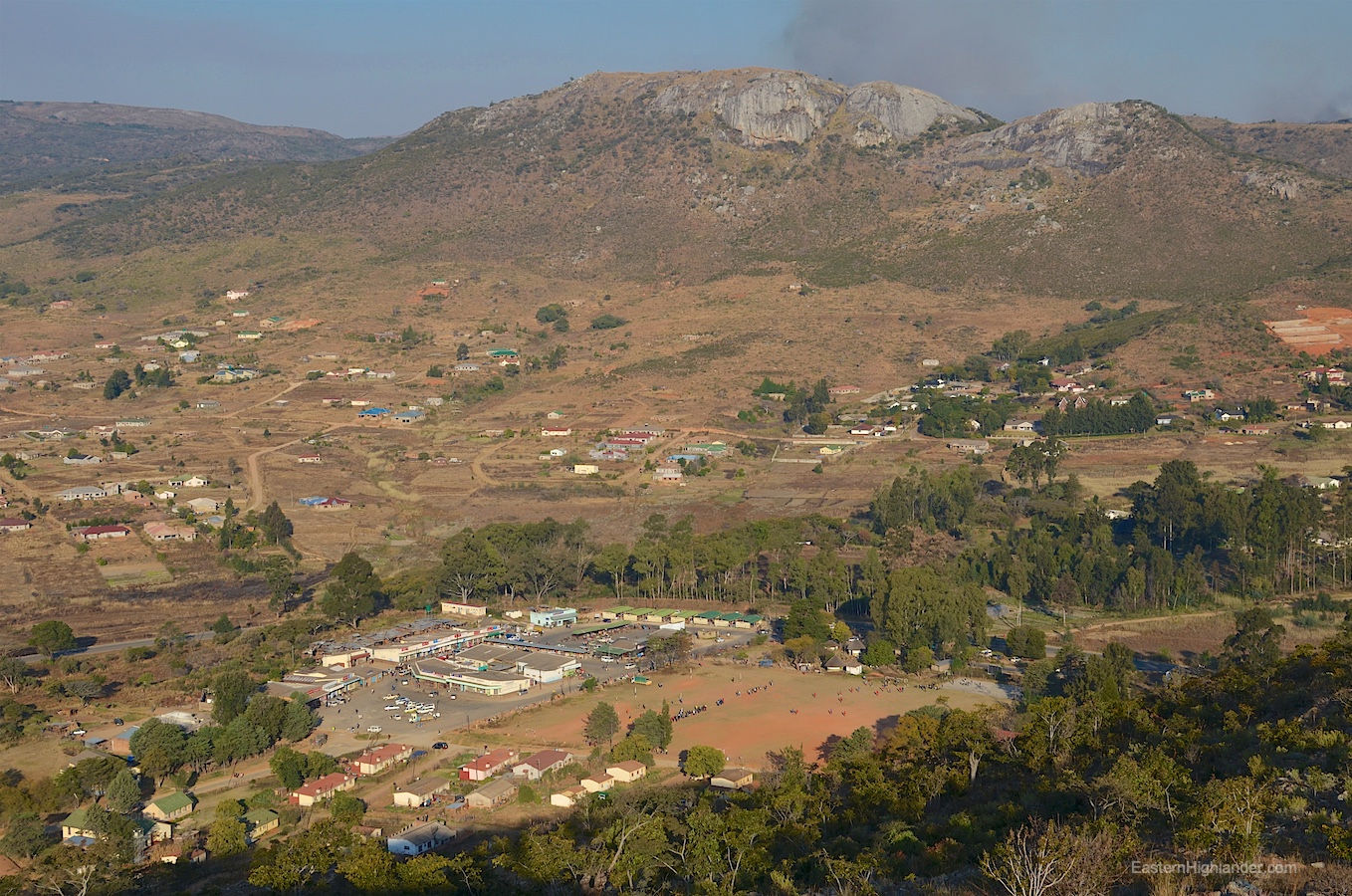
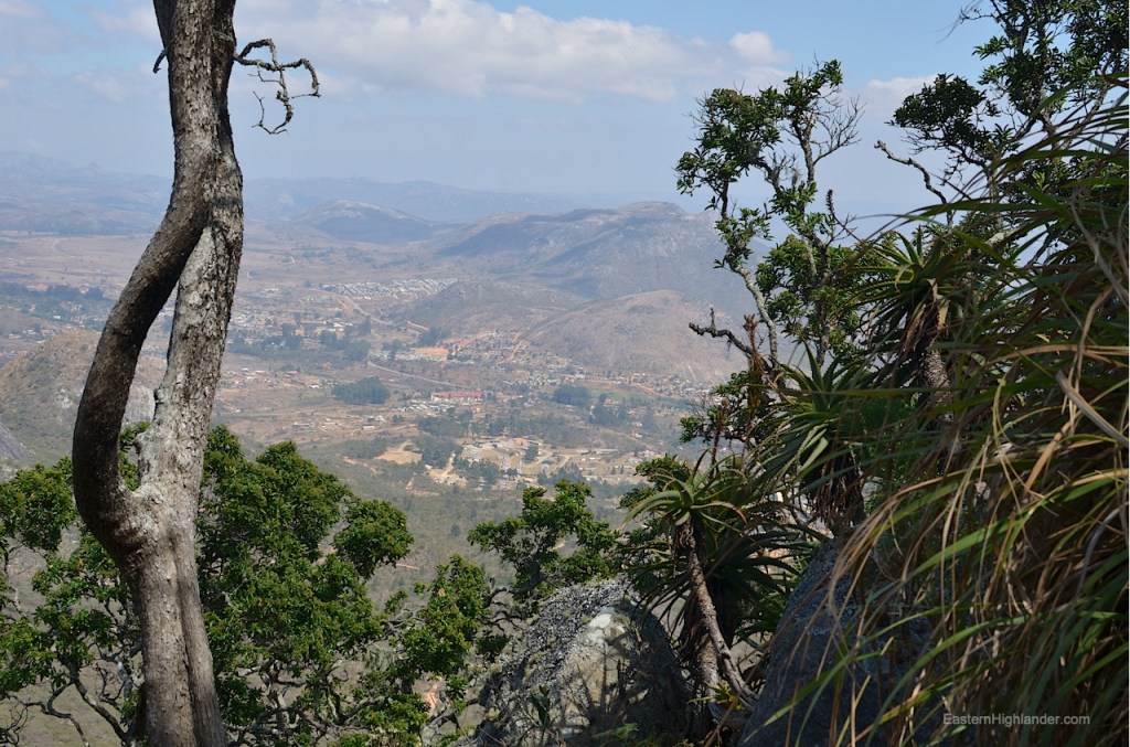
First, and by far the easiest and simplest, is the hill behind Nyamhuka 1. As a warm-up to the other three walks do it mid-to-late afternoon so you get the sun behind you when looking down on the town and the Nyamhuka rank / market area surrounded by now orange glowing hills – at least in August.
Simply park at the top of the Nyamhuka residential area (up past the school, where you can see the large water tank) and follow the obvious path in the direction of the saddle. Before you get there turn right (ie northwards) and again follow the easy path climbing now towards the top of the hill. Literally 10 to 20 mins to get up there for some substantial views as the sun starts setting. With light scrambling you can find your way to the ‘end of the hill’ now looking northwards.
The next three walks are a significant step up in adventure level, duration, and hill-walking ability (planing, route finding and exposure/steepness).
Second, the peak south of the Bepe Park residential area that towers over the houses trying to climb its gentler slopes. Park at the end of the Bepe Park access road and basically start walking up aiming for the west side of the hill. You will soon come across the path(s) used by … probably the firewood extractors … over some worn out ancient terracing with the stones bonded together (not dry-stone). You will start to see the stream valley and the pipes tracking out of it. Follow the stream up, keeping it on your left (to your west). The whole place had just burnt down in a bush fire so maybe my going was easier that normal. About half way up there is a hidden saddle and mini-peak on your right side (east side). This contains circular Shona stone work likely due to its strategic position. Too many trees for any photos down though. Traverse back to your main line of ascent; there seemed to be numerous animal / human paths to follow making it easier than you original line. It is going to be steeper now so just go for it and head up – it is not that far!
First is a minor top or open plateau for views down to Nyanga. Curiosity will take you higher along the crest of the hill. There was some slight scrambling / exposure (or that’s how it felt); just take a deep breath and press on – its worth it for the views, and easier coming down as your confidence will be higher knowing where you are going. Flattens out on top so you can just relax and take pictures. I got as far as I felt like going on my own ie until I saw the rising domes of the lesser peaks below me to the south west, then I simply retraced my steps. About three hours in total with many photo stops. There were separate adventures with a snare and with a mhembwe so I had evidently received for the 5 star option.

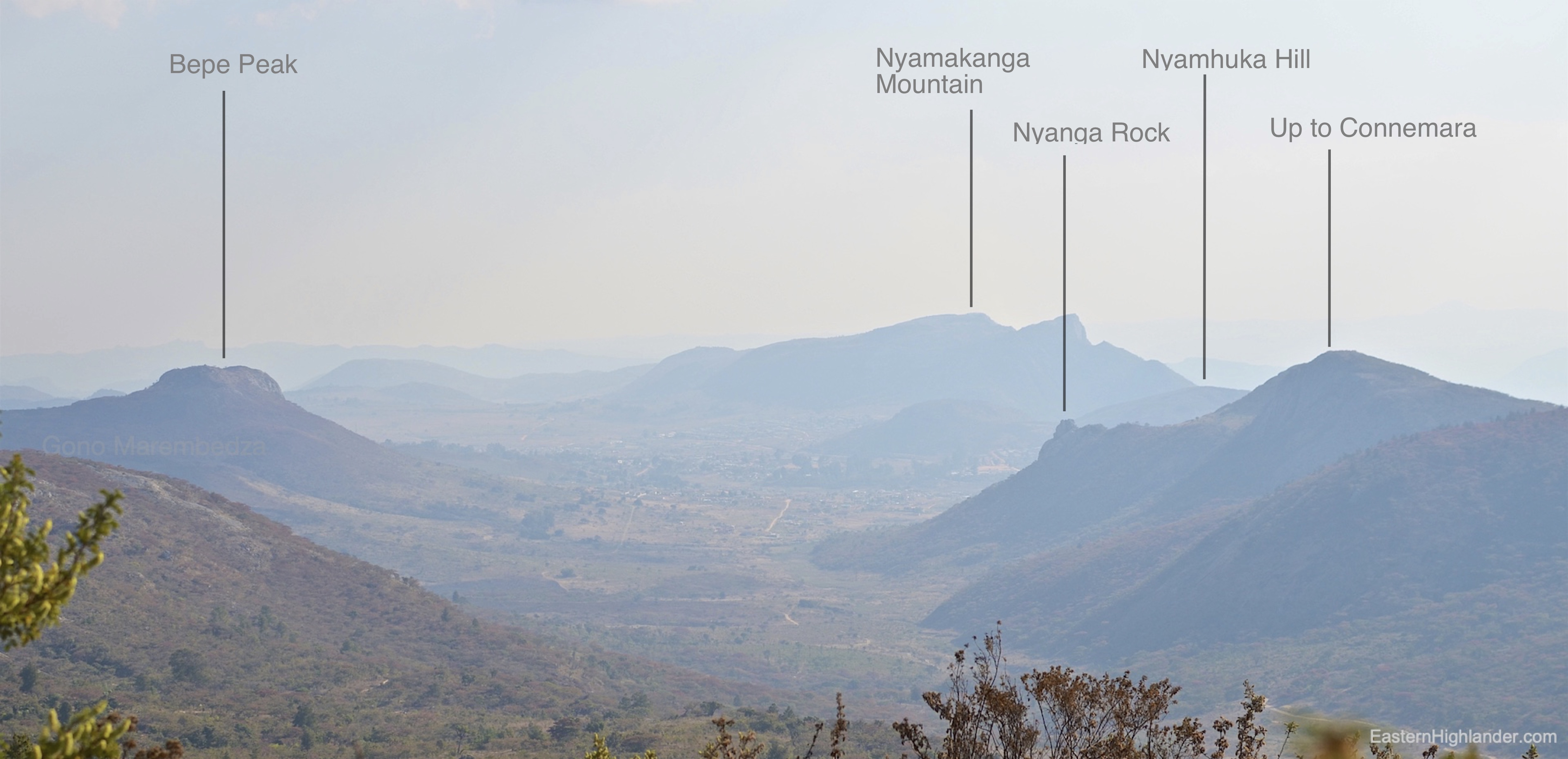
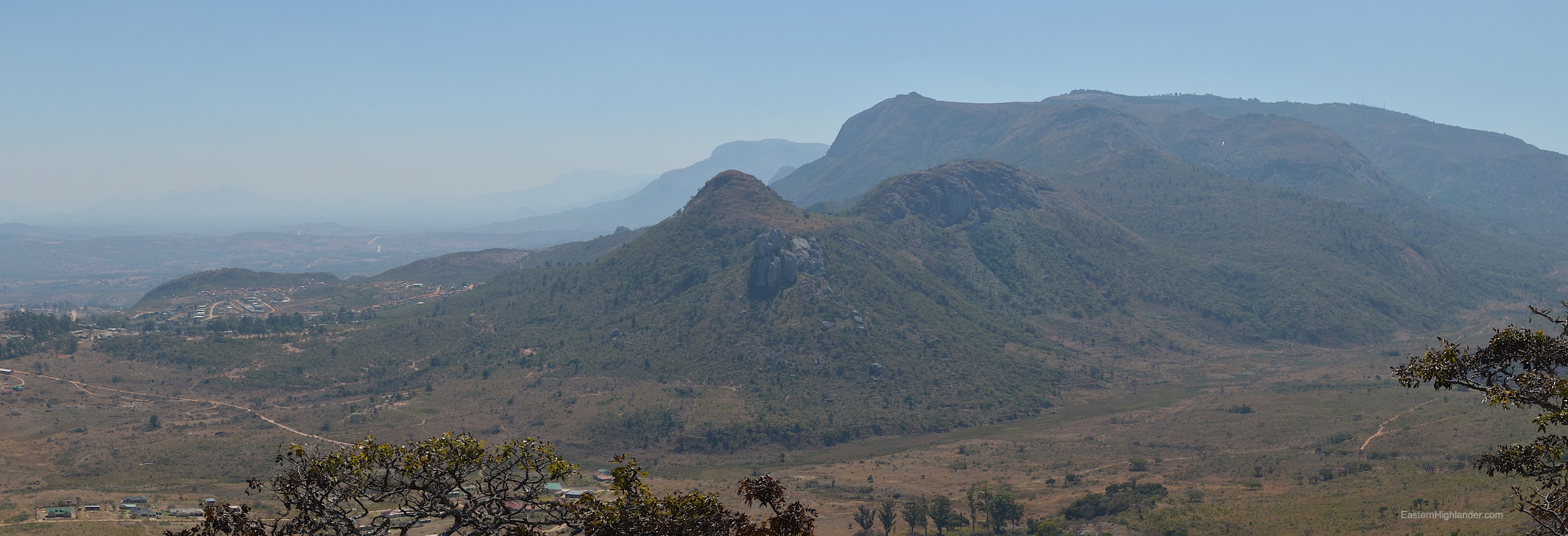
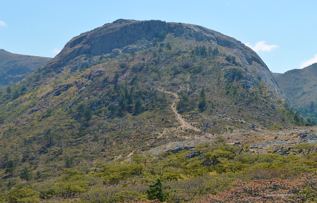
Third, Nyamakanga mountain to the west of Nyamhuka 2 residential area. Initially it was incorrectly marked on Google Maps (and every other online map so they must all be sourcing the same data) by about 200 metres too far to the west. There is now a marker on Google Maps called ‘Nyamakanga Trig Point’! In any case the mountain is unmissable as you come into Nyanga from Troutbeck or Juliasdale; the trouble is it looks too steep and impossible. One answer is to go on to Google Maps and see how to tackle it from the western side.
Just so you know: detailed trip planning using Google Maps / Google Earth may possibly get you into hot water particularly in terms of the actual steepness of the terrain you mapped out whilst sitting in front of a screen. Can you tell this is experience speaking? Fortunately Google Maps is really useful for finding dust roads and paths to get you in and about the places you want to walk in.
All this being said I followed what I had spec-ed out on Google and took the dust road past Nyamhuka 2, towards Nyarumvurwe (west) and turned off it to the left (south) once I had passed the mountain (note that it is going to look quite big at this point). Travelling slowly make your way as far as you dare. The road just gets tougher and (much) steeper in short stretches. I ended up: walking, checking, returning, driving in stages. Anyway, I eventually found some other outdoors enthusiast (digging deep holes in the ground) who showed me where I could park in proximity to their camp.
My efforts to find a path up did not go quite as planned and I was forced to scramble between the sparse low Msasa-type trees in-order to gain the ridge ahead and to the south. This became slightly easier and I found two Shona dry-stone circles nestled in a hidden spot. Soon I came across a bizarre but welcome way up consisting of a ‘path’ of cleared rounded stones. Tough to walk over but easier and clearer than any alternative.
Based on my later path down my advice for ascending is to head up diagonally to the left (south) as there are too many paths to count in this area – as well as a very deep hole right in the middle of the path!
So, you are going to get up onto the first plateau and quickly walk to the other side past some pines (now logged) and an open patch of rock. Back up a bit and just start heading up in the direction you know you want to go (roughly north at this point). There is a bit of scrub to get through; here you sense someone has been doing the same thing but without coalescing into one path, and soon enough the way becomes obvious and easier.
Pretty much plain sailing (up) now. Perfect views west, south and east – though you may stay on the west side as you can return later walking on the east side. You will see more Shona dry-stone work in and around the trig point and below to the east on the rather massive plateau you can’t quite believe exists up here. This means you are walking east, over to look towards and down on Nyanga. It also means you can see a whole new adventure and a whole new valley of trees, some indigenous and some pines (now logged), to the north. I found a way down and through to the east curious about the logging (how are they going to get the planks out from the top of a domed hill – manpower presumably?). I was also searching for evidence of a way down directly to Nyamhuka 2 whilst at the some time contemplating a giant circular walk back to the car and wondering if it would be quicker than retracing my steps. As it became steeper where the stream narrowed and disappeared, discretion overcame valour and I made the decision to retrace. Once back at the main plateau I contoured along the eastern side saving a bit of re-ascent and getting in some more pictures of the Nyanga to Juliasdale panorama. Soon after the first lower plateau on the way down I found those paths now heading downwards and northwards to my right. I took one of many going in the general direction of the car for a quicker, easier trek back. This was a 5 hour trip with no picnic stops but many photo breaks including an augur buzzard. If you went to the trig point and back you would knock off an hour anyway. For me the premier day out in Nyanga with the Bepe hill coming second.
4. Walking up towards Connemara / the hill behind ‘the government’ (as it is known) residential area
It doesn’t have a name that I know of but it is unmistakable in its presence in Nyanga – this is the escarpment a few hundred metres up to the east where lies Troutbeck / Connemara / World’s View / Bende and continues on northwards further than I know. The same escarpment that is Mount Nyangani to the south.
There is a walking route up / down to Troutbeck through the Bepe Park valley that I haven’t done yet but this is not that walk!
Get to ‘the government’ residential area by turning right off the tar (if you are coming from the south) towards the main police station / hospital then soon turn left where it is signposted to District Administrator’s office. Follow your nose onwards and then to the right, steeply upwards on the rough dust road. I parked below the very visible water tank (Google Maps). The road does continue – actually for kilometres – but this is a walk and the road looked steeper and rougher for a bit, though it does mellow out for a long stretch before becoming really difficult. Yes, it was likely made by those extracting from the land, and there is a bit of ‘forestry’ still ongoing. Much of the area is covered in a strange mix of indigenous msasa type trees and pine on the way up from here. Both have been / are being troubled by humans. I wonder how many years it will take for the pine to outgrow and dominate the msasa?
If you happen to meet two gents walking down who nod and say ‘yes’ they are walking down from Connemara it gives you hope for a successful, though intriguing, day ahead. It is a hot walk up following the road/track to the first plateau / logging area (now you know why the dust road was pushed up to here) which makes a great stop for pictures when you scramble south through the low trees for a better view down to Nyanga.
Now the going gets much steeper and you are following the one path up. There are spectacular views and presumably a spectacular drop to the west now. Persevere on up. It is steep, before easing up. Now the alpine wind is reminding you that it is colder when you stop. Ahead and up lies the last and steepest section that is really a scramble up through a 3 metre wide cleft in the rock.
Again it is easier that you would imagine on the way back down so please just push on up! Once though this you have made it. I stopped soon after as it looked like plain walking (famous last words) onwards to the Connemara area. In retrospect there could well be further ‘interesting’ paths to find tracing the lip of the escarpment northwards towards World’s View. From below there is a very characteristic set of rocks further onwards from this point when viewed from Nyanga. After taking more pictures do a 180 and re-trace your path down. The only short cuts were reserved for the lower wooded area where it was possible to cut off long loops in the dust road by following the small but well trodden tracks taken by the professional walkers transiting to / from Connemara.
This is a fine Alpine style walking ascent but you are further away from Nyanga now so the pics feel more hazy and distant compared with the immediacy of the other peaks.
3 hours total plus a bit more if you need a formal rest at the first plateau
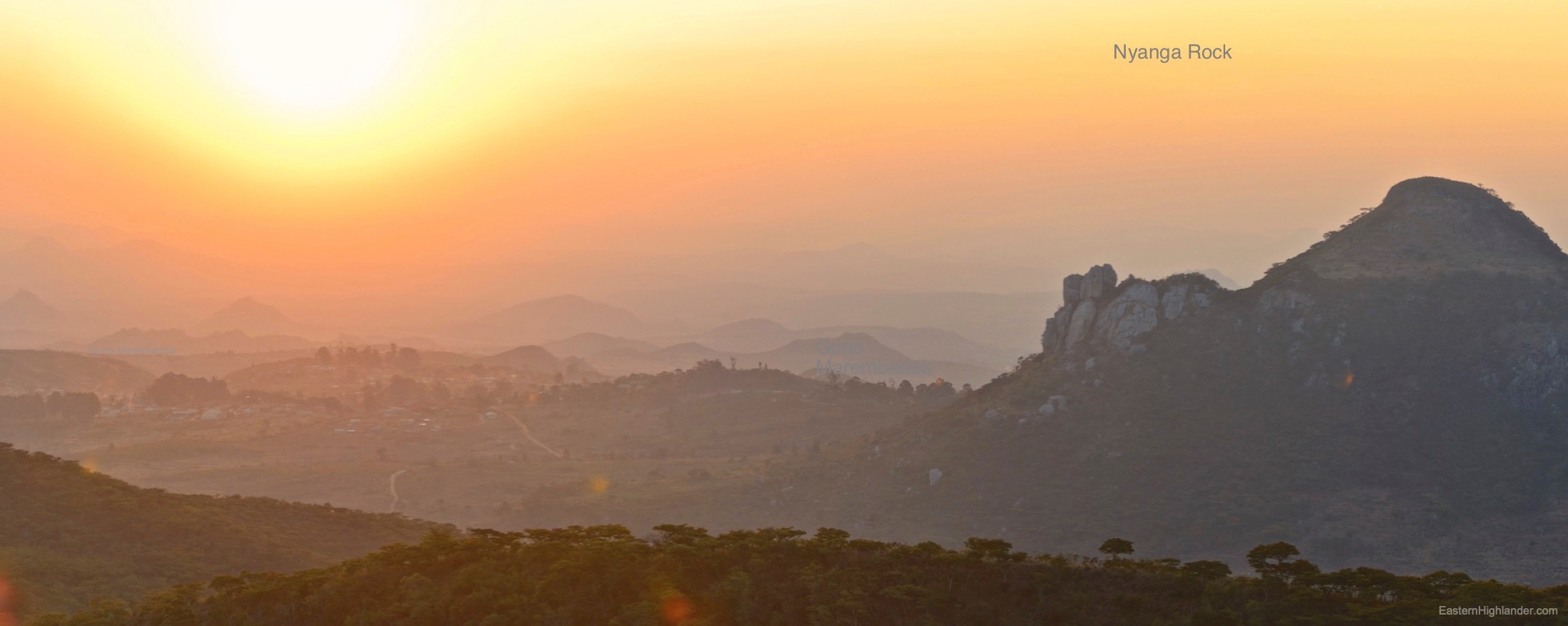
5. Nyanga Rock. Then there is a fifth possibility taking you to an exciting landmark in Nyanga: the prominent, vertical, rocky outcrop that is aways somewhere in the distance when you picture Nyanga. There are enough clues in the preceding walks for you to figure this one out!


Next an image of all the walks in one go:
In chunks: